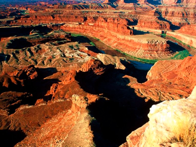
Dead Horse Point

Dead Horse Point State Park is perhaps Utah's most spectacular state park. Dead Horse Point is a promontory of stone surrounded by steep cliffs near Moab, Utah. The overlook at Dead Horse Point is 6,000 feet above sea level. Two thousand feet below, the Colorado River winds its way from the continental divide in Colorado to the Gulf of California, a distance of 1,400 miles.
From the overlook, canyon erosion may be viewed on a grand scale. This erosion process has taken approximately 150 million years. Much of it is caused by the river slicing down into the earth's crust as land is forced upward. These powerful forces are still sculpting the fantastic shapes of the precipitous bluffs and towering spires.
Before the turn of the century, mustang herds ran wild on the mesas near Dead Horse Point. The unique promontory provided a natural corral into which the horses were driven by cowboys. The only escape was through a narrow, 30-yard neck of land controlled by fencing. Mustangs were then roped and broken, with the better ones being kept for personal use or sold to eastern markets. Unwanted culls of "broomtails" were left behind to find their way off the Point.
Climate: Spring (April through May) and Fall (September through October), daytime highs average 60 to 80 F and lows average 30 to 50 F.
Summer temperatures often exceed 100 F, making strenuous exercise difficult. Late summer monsoon season brings violent storm cells which often cause flash floods.
Winters are cold, with highs averaging 30 to 50 F, and lows averaging 0 to 20 F. Though large snowfalls are uncommon (except in nearby mountains), even small amounts of snow or ice can make local trails and roads impassable.
Dead Horse Point