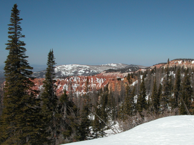
Cedar Breaks

Resting on top of the Colorado plateau, at over 10,000 feet in elevation, this breathtaking view awaits. Millions of years of sedimentation, uplift, and erosion are carving out this giant amphitheater, that spans some three miles, and is more than 2000 feet deep.
Deposition
Deposition at Cedar Breaks started about 60 million years ago. The plateau that Cedar Breaks is currently located on was much lower than it is today. During this time, the area was completely covered by a lake. This lake became known as Lake Claron. The lake was 70 miles wide and 250 miles long. Surrounding highlands began to erode away and these sediments were carried away by wind and water into LakeClaron. These sediments settled at the bottom of this lake. Algae that naturally lived in the lake would eventually die forming a paste that cemented all the sediments together to form the sedimentary rock that is visible at Cedar Breaks today. The sedimentary rock visible at Cedar Breaks is limestone. The colors visible in the rock come from various amounts of oxidized irons (red and orange hues) and manganese (purple hues). This entire formation became known as the Claron formation or Pink Cliffs.
Uplift
Cedar Breaks is located near a major fault known as the Hurricane fault. This fault is 100 miles long and runs parallel to I-15. It became very active about 10 million years ago, raising the LakeClaron bed to its current elevation of 10,350 feet above sea level. The Hurricane fault is known as a normal fault. The fault is still active today, but because it moves at such a slow rate, it is hard for one to notice the movement.
Erosion
Ever since the rocks were uplifted, they became exposed to the various erosion elements. There are three types of erosion apparent at Cedar Breaks: chemical, water, and wind erosion.
Climate: Summer Day-time temperatures range between 50 and 60 degrees F (10 to 15 degrees Celsius). Night-time temperatures range between 20 and 30 degrees F (-6.7 to -1.1 degrees Celsius). Wind and afternoon thunderstorms are very common throughout the year. Be prepared for cooler temperatures and the possiblity of snow.
Winter at Cedar Breaks can be a wonderful experience for those prepared for extreme winter conditions. Although Cedar Breaks Scenic Drive is closed by deep snow during the winter months (late-Nov to mid-May), winter access into the park by skis, snowshoes, or snowmobiles is a wonderful way to experience the sub-alpine beauty of the park. This past winter a yurt was built by the Alpine Pond Trailhead for winter visitors to stop by and warm up with a hot cup of cocoa (outside of the yurt, there are no other visitor facilities available). The Yurt is staffed by volunteers on the weekends during the winter season.
Elevations range from 10,662 feet down to below 8000 feet at the bottom of the canyon.
Cedar Breaks